Driving into Yosemite Park after miles of winding, treacherous mountain roads is both a relief and a joy. Entering from the western front does not yet reveal the majesty of the famous Yosemite Valley or the granite monoliths so often pictured in publicity photos. We are headed for the Crane Flat Campground on Rt 120, the main road through the western portion of the park, still some 17 miles from the more famous and congested regions.
Crane Flat with 271 sites is one of the more crowded campgrounds in the park, but is located outside of the valley and is much less noisy than those campgrounds in the center of the action in the park. The sites can be a bit out of level, necessitating leveling blocks at many sites, but they are very large and nestled into a deep grove of towering trees with the usual picnic table, fire ring and bear proof storage box. There are also bathrooms with running water, flush toilets and a dish washing sink. (no electric hook-ups or showers in any of the park campgrounds.) Crane Flat at 6200 feet is conveniently located adjacent to three roads that provide access to the interior of the park and is also across the road from a gas station and camp store.
Note: There are black bears at Yosemite and the rangers are quite adamant about bear proofing your site, including no food or perfumed toiletries allowed in your car overnight. RV’s are excepted from this rule. Bear spray is also prohibited.
Travel in the park is difficult with any size vehicle due to the crowds but larger rigs risk further complications finding parking at the various view points and parking lots. We were fortunate to be able to share a car with friends camping with us but I would recommend renting a vehicle if you plan to spend days of travel throughout the park and are driving a larger RV. And many days are certainly needed to adequately explore this gem of a National Park in the Sierra Nevada mountains in eastern California.
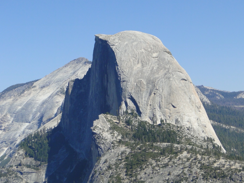
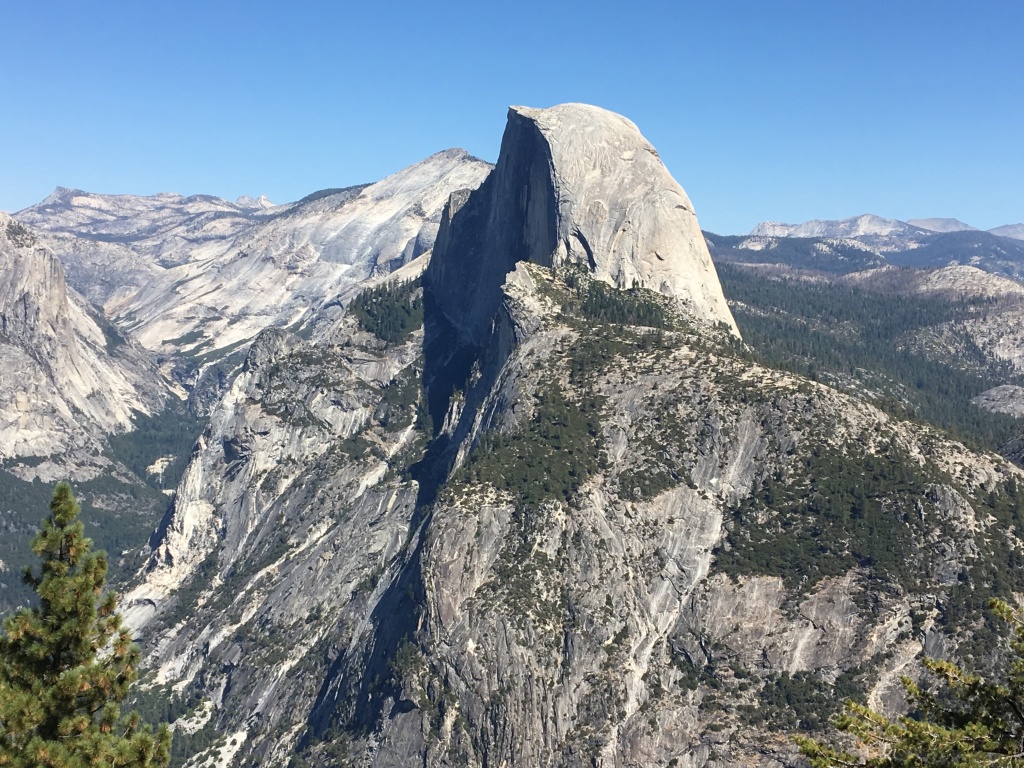
On day one we visited the iconic Yosemite Valley, a 7.5 mile long granite bowl, only 1% of the park area, but the most heavily visited region by far. The valley is accessed via the Wawona Tunnel portal that exposes a stunning first glance looking eastward. Expect crowds, big crowds, no matter what season you visit, for the valley is home to the massive granite summits of El Capitan and Half Dome, two of the most famous rock faces in the world as well as the Yosemite Falls, the highest waterfall in North America. You are advised to take any parking space that you can find and then travel around the valley on the free shuttle buses. In the valley, at or near the Yosemite Village, is found the Yosemite Valley Visitor Center and Theater, food concessions, a store, the Majestic Yosemite Hotel (formerly the Ahwahnee), the Yosemite Valley Lodge and trailheads to many of the hiking trails.
While driving through the Valley we were also fortunate to stop and visit with a patron with a telescope trained on climbers of the iconic El Capitan. We recently viewed the amazing movie, “Free Solo” of a climber who made this climb sans ropes. Do see it if you plan to visit Yosemite.


We did escape the crowded valley though with several short hikes including Mirror Lake, a 2 mile round trip hike to the former lake, now an almost totally dry river bed, and a 1 mile round trip hike to Lower Yosemite Falls. Be advised that the many waterfalls in the park begin to dry up later in the summer and the very best time to see these spectacular displays is in the spring.


Day 2 we traveled to the southern end of the park to visit both Glacier Point and the Wawona region. Glacier Point is a magnificent mountain top reached by road that offers a commanding view of the Yosemite Valley below. At the summit is a beautiful stone shelter, walking paths to various vantage points, views of several waterfalls as well as a particularly stunning view of Half Dome.


36 miles south of the Valley is the Wawona Visitors Center where a free shuttle bus ferries patrons from the parking lot to the Mariposa Grove of giant sequoia trees. This ancient grove has several hundred mature sequoias, two of which are among the 30 largest giant sequoias in the world. The granddaddy of these, Grizzly Giant, counted as the 25th largest tree in the world is 210 feet tall with a circumference of 92 feet and is estimated to be between 1900 and 2400 years old. The hikes in the grove vary in length and degree of difficulty but access to many of these giant trees is easily reachable from the bus stop.


Photo by Jack Ostrofsky
On our final day in the park, we drove the Tioga Road east towards the eastern entrance to the park at Lee Vining. This 58 mile long road takes you to the Yosemite high country as it rises to nearly 10,000 feet at the Tioga Pass, and winds through broad sub-alpine meadows surrounded by even taller granite domes and peaks. The drive is dotted with lakes, fields and granite mountains that include some that are easily hiked. At Olmstead Point, we hiked the dome on the north side of the parking lot for a stunning 360 degree view that included Tenaya Lake, Mt. Hoffman at 10,850 feet, Cathedral Peak at 10,940 feet, and a very special north side view of Half Dome where, with binoculars, you are able to see hikers climbing the cable route. This 16 mile round trip cable assisted hike is by permit only and is not allowed if there is any chance of rain or lightning as the granite face becomes incredibly slippery. Two weeks before our visit a visitor fell to her death on this route, apparently due to slick conditions.
Note: Olmstead Point is named in honor of Frederick Law Olmstead, considered the father of American landscape architecture (NY Central Park) and his son Frederick, Jr. as they both were involved with design and preservation of the land at Yosemite.


Continuing east from Olmstead Point, the famous Tuolumne Meadows begins to unfold below us surrounded by peaks and domes that look down upon these glorious fields. Though the true magic in the meadow is in spring with blooming wildflowers galore, the spread of the landscape and the adjacent creeks and rivers captures the eye nonetheless.


Cresting the Tioga Pass at 9,945 feet, we slowly descend to the Eastern exit of the park and leave Yosemite after 4 days of wonder and awe. Of Yosemite, John Muir wrote, “It is by far the grandest of all the special temples of Nature I was ever permitted to enter.”
Just north of the park road, Mono Lake comes into view as we enter the town of Lee Vining. The Mono Lake Visitor’s Center, a beautifully constructed post frame building, offers up the history and unique biology of this lake that has no in or outflow. (I mention the building as the beauty of the construction alone is worth the stop.) A few hours north brings us to Carson City, Nevada to visit with some old friends who become our tour guides for the Lake Tahoe area the next few days. The first visit was to Incline Village on the north shore of the lake. This upscale area is known for its wide views and outstanding colors of the lake water.

Day 2 takes us to the south shore of the lake and through the town of South Lake Tahoe where we also view the spectacular Emerald Bay and hike a few short trails that offer up even more magnificent views of the surrounding mountains and the lake. Many of the trails intersect with the Tahoe Rim Trail. This trail that loops the Lake Tahoe Basin is 165 miles long and climbs from 6,240 feet to 10,330 feet in elevation change.


After a very relaxing and restful visit in Carson City, we leave to head back west to a rendezvous with several friends in the San Francisco Bay area. Though there are several options for routes through the mountains we opt for the easier drive across I-80, the famed Donner Pass. A rain storm was in the forecast but we were truly shaken as the temperature dropped rapidly upon our ascent to 7,239 feet and as it hit a balmy 32 degrees, the rain changed to snow.

Descending quite slowly on the California side of the mountain, to our delight the temperature rose as rapidly as it had fallen and the sun actually made an appearance in a relatively short period of time. Within 3 hours we arrive in Bolinas, Ca. on the north side of San Francisco Bay for a brief visit with an old friend. This hidden gem within only a few miles of the Golden Gate Bridge as the crow flies, is home to many artists who crave the solitude but enjoy the proximity to the city by the bay.


After a wonderful tour of Bolinas and the adjacent lagoon, we make our way across the mountains to the Golden Gate Bridge and a week- long visit/respite with some friends in San Francisco. Though our journey to date has been primarily in search of rural scenery, this city holds a special place in our hearts for several reasons so I’ve included a few photos of some iconic spots.


Our next destination is San Simeon and the Hearst Castle where we will begin the next chapter. Until then, peace.
Jay & Ellen

Exquisite photos with pictures of some of my favorite places. Thank you and happy travels to you both. Love, cb
LikeLike
Beautiful pictures,we went to Yosemite in April 2 years ago and had a little snow walking around the Giant Sequoias,nice to see the fall scene.Thanks for sharing this,SF pics great too😎
LikeLike
Hi Jay its Jay! A few things.. 1. That’s the absolute best place to see the Golden Gate Bridge. I spent a few hours there with friends. The bigger question is ….did you, or did you not get chowder in a sourdough bread bowl while you were there? 2. Woodpeckers are inherently jerks (or so I learned from a childhood of watching cartoons) cool pic though! 3. Those climber pics are amazing! Hope you guys are having fun!
LikeLike
Another great entry. Pics are, as usual, outstanding and your descriptions convey the awe you guys have for Yosemite. Hope you enjoyed the Castle and had a nice conversation with Rosebud. Stay safe and sound.
LikeLike